

![]()
![]() I have aerial photos of the entire line. These were shot by the US Department of Agriculture back in the 40s and 50s and on up. I bought photo indexes of the area and put together lists of the individual frames that followed the whole RR. I then ordered 10" x 10" contact prints from the original negatives. These worked well for getting a feel of the line, but the 40" x 40" Mother of All Prints are the only way to really study the detail of the area, so that's what I bought. They're big and heavy and expensive, but worth all the trouble. Most of the aerial photos from Johnson City over to Linville were shot in 1953... a few from 1952. I have Cranberry from 52 and 53, I'll post both to see the difference a year made. I have Linville over to Boone from September 1940, just a month after the flood. These photos aren't as sharp or well done as the 1953 photos, but hey, they're from right after the flood, what more could we ask for. And remember, the photo prints I have are 40" x 40" and I can only scan a section about 8.5" x 11" for each shot that I'm posting, so you're only seeing a small window in the overall aerial photo. I'm orienting all these so that north/south is straight up and down so that if there's any discussion about them, directions should be easier to follow.
I have aerial photos of the entire line. These were shot by the US Department of Agriculture back in the 40s and 50s and on up. I bought photo indexes of the area and put together lists of the individual frames that followed the whole RR. I then ordered 10" x 10" contact prints from the original negatives. These worked well for getting a feel of the line, but the 40" x 40" Mother of All Prints are the only way to really study the detail of the area, so that's what I bought. They're big and heavy and expensive, but worth all the trouble. Most of the aerial photos from Johnson City over to Linville were shot in 1953... a few from 1952. I have Cranberry from 52 and 53, I'll post both to see the difference a year made. I have Linville over to Boone from September 1940, just a month after the flood. These photos aren't as sharp or well done as the 1953 photos, but hey, they're from right after the flood, what more could we ask for. And remember, the photo prints I have are 40" x 40" and I can only scan a section about 8.5" x 11" for each shot that I'm posting, so you're only seeing a small window in the overall aerial photo. I'm orienting all these so that north/south is straight up and down so that if there's any discussion about them, directions should be easier to follow.
![]()
![]() This shot is of the Valley Creek area. The site of the RR bridge should be just about in the middle of the photo. You should be able to follow the line easily thru here. I will point out something interesting. If you follow the Doe river up and to the right from the Valley Forge bridge, there's a heavy line of trees on the north side of the river. Follow it up a short distance and you'll see a definite "finger" of trees jut out from the main group. This finger points NW. This is where the Laurel Fork Ry crossed that field and crossed the river on a wood truss bridge. If you follow that finger of trees SE across the river, you'll see that the RR ran across the road that parallels the river, and the road that runs SE and turns ESE is built on the Laurel Fork ROW. You can follow the road to where it ends at a house and see the double tree line with the ROW in it. Lot's of stuff to look at, explore and ask questions. The next 3 that I'll post will be at Hampton and Tunnel 1 and Coal Chute. These have all been discussed recently and folks seemed to be interested in them.
This shot is of the Valley Creek area. The site of the RR bridge should be just about in the middle of the photo. You should be able to follow the line easily thru here. I will point out something interesting. If you follow the Doe river up and to the right from the Valley Forge bridge, there's a heavy line of trees on the north side of the river. Follow it up a short distance and you'll see a definite "finger" of trees jut out from the main group. This finger points NW. This is where the Laurel Fork Ry crossed that field and crossed the river on a wood truss bridge. If you follow that finger of trees SE across the river, you'll see that the RR ran across the road that parallels the river, and the road that runs SE and turns ESE is built on the Laurel Fork ROW. You can follow the road to where it ends at a house and see the double tree line with the ROW in it. Lot's of stuff to look at, explore and ask questions. The next 3 that I'll post will be at Hampton and Tunnel 1 and Coal Chute. These have all been discussed recently and folks seemed to be interested in them.
![]()
![]() Here's another aerial photo. This one is just north of the other photo, in fact the field where the Laurel Ford ran overlaps into this photo. If you follow that finger of trees across the field, you can see a cut through another group of trees where the Laurel Fork headed over towards the ET ROW and followed it back into Elizabethton. In fact, it looks like you can see Laurel Fork ROW to the east of the ET ROW north of the drive-in on the opposite side of a line of trees. May be a farm lane, but it's hard to tell. Laurel Fork had been gone over 20 years when these photos were made.
Here's another aerial photo. This one is just north of the other photo, in fact the field where the Laurel Ford ran overlaps into this photo. If you follow that finger of trees across the field, you can see a cut through another group of trees where the Laurel Fork headed over towards the ET ROW and followed it back into Elizabethton. In fact, it looks like you can see Laurel Fork ROW to the east of the ET ROW north of the drive-in on the opposite side of a line of trees. May be a farm lane, but it's hard to tell. Laurel Fork had been gone over 20 years when these photos were made.
![]() The Coal Chute (this should make Robert Helm happy) is about mid photo. You can see the concrete walls and see shadows of the concrete vertical supports that the track ran on up on top of the structure. I think this view will make it a little easier to imagine how this thing operated, especially since there don't seem to be any real good shots of it from ground level. You can get a feel for the height of the structure too by comparing the shadows cast by its walls in comparison to the shadows cast by the nearby houses.
The Coal Chute (this should make Robert Helm happy) is about mid photo. You can see the concrete walls and see shadows of the concrete vertical supports that the track ran on up on top of the structure. I think this view will make it a little easier to imagine how this thing operated, especially since there don't seem to be any real good shots of it from ground level. You can get a feel for the height of the structure too by comparing the shadows cast by its walls in comparison to the shadows cast by the nearby houses.
![]() Just north of the chute is the very distinctive pattern of the drive-in. Unmistakeable. If you go over there in person, you should be able to get a feel for where coal chute structure was by gauging how far it was from the entrance to the drive-in, which is still there. I think the cut-over from the old highway down to the new highway is about where Coal Chute used to be. That whole area just south of the drive-in has been cut up a good bit for the new highway. If you can count the houses and streets then and now, you should be able to pinpoint exactly where it was.
Just north of the chute is the very distinctive pattern of the drive-in. Unmistakeable. If you go over there in person, you should be able to get a feel for where coal chute structure was by gauging how far it was from the entrance to the drive-in, which is still there. I think the cut-over from the old highway down to the new highway is about where Coal Chute used to be. That whole area just south of the drive-in has been cut up a good bit for the new highway. If you can count the houses and streets then and now, you should be able to pinpoint exactly where it was.
![]() This group of photos were all shot on June 6, 1953. And I'm guessing here but it looks like they were shot early to mid-morning. So the coal chute structure was still there in 1953, be interesting to know when they demolished it.
This group of photos were all shot on June 6, 1953. And I'm guessing here but it looks like they were shot early to mid-morning. So the coal chute structure was still there in 1953, be interesting to know when they demolished it.
![]() -- To answer Mike West's question about Coal Chute, I think the track was, and always was, layed out exactly as it is shown on my maps. The switch for going up on top of the chute was on the south end of the structure, they loaded coal out of the east side of the structure, and the mainline track was on the east side of the structure with the third rail on the "chute" side (west side) of the track. The photo on page 206 of John Waite's book is correct, it's looking from Elizabethton toward Hampton. The road is on the right side of Coal Chute when looking this direction. You can tell quite well how tall it was above the road in this photo, and that it sat right up against the road. I imagine it was pretty much a "no nonsense" road hazard for anyone not paying attention.
-- To answer Mike West's question about Coal Chute, I think the track was, and always was, layed out exactly as it is shown on my maps. The switch for going up on top of the chute was on the south end of the structure, they loaded coal out of the east side of the structure, and the mainline track was on the east side of the structure with the third rail on the "chute" side (west side) of the track. The photo on page 206 of John Waite's book is correct, it's looking from Elizabethton toward Hampton. The road is on the right side of Coal Chute when looking this direction. You can tell quite well how tall it was above the road in this photo, and that it sat right up against the road. I imagine it was pretty much a "no nonsense" road hazard for anyone not paying attention.
![]()
![]() Here's another photo, this time we're going south from where we've been, down to tunnel 1. This photo doesn't have a lot of ET trackage on it, but what's here is interesting. This is one where looking at the whole photo at one time is a good thing... for getting a feel for what you're looking at. To start with I included the upper right hand part of the photo 'cause you can see the scar left by the Valley Forge manganese mine. I'm not sure the big light gray crescent shaped scar is from the mine, but the small white one is. Plus the larger medium gray opening between the large and the small ones is from the mine. Anyway, using my manganese mine map from Jan/Feb/Mar 2001 Stemwinder back issue, you can kinda see how they got the manganese down to the Laurel Fork trackage.
Here's another photo, this time we're going south from where we've been, down to tunnel 1. This photo doesn't have a lot of ET trackage on it, but what's here is interesting. This is one where looking at the whole photo at one time is a good thing... for getting a feel for what you're looking at. To start with I included the upper right hand part of the photo 'cause you can see the scar left by the Valley Forge manganese mine. I'm not sure the big light gray crescent shaped scar is from the mine, but the small white one is. Plus the larger medium gray opening between the large and the small ones is from the mine. Anyway, using my manganese mine map from Jan/Feb/Mar 2001 Stemwinder back issue, you can kinda see how they got the manganese down to the Laurel Fork trackage.
![]() Speaking of the Laurel Fork, you can see the imprint from it as it followed the Doe River around that big loop. The shadow is hard to see, but it's there, pretty close to the river. The LF ROW coincides with the southern end of old 19E where it ties back in with new 19E. I think new 19E was built on top of the LF ROW from there on down towards Hampton. The old 19E shows up well, having just been replaced by the new highway in 1943. Both those old 19E bridges are still there including the one that crosses the river from within the loop. Not sure what they were doing out there inside that loop of the river, but it looks like they may have used it to dump alot of the fill from where new 19E went thru the ridge. Kind of interesting though. John Waite and I walked out into that loop of the river in February of 2003 when there was about 4 inches of snow on the ground. We couldn't get down to that southern bridge, but standing inside that loop you could easily see at about our level, the ROW of the Laurel Fork. That ROW could easily be accessed by going in the southern intersection of 19E and old 19E.
Speaking of the Laurel Fork, you can see the imprint from it as it followed the Doe River around that big loop. The shadow is hard to see, but it's there, pretty close to the river. The LF ROW coincides with the southern end of old 19E where it ties back in with new 19E. I think new 19E was built on top of the LF ROW from there on down towards Hampton. The old 19E shows up well, having just been replaced by the new highway in 1943. Both those old 19E bridges are still there including the one that crosses the river from within the loop. Not sure what they were doing out there inside that loop of the river, but it looks like they may have used it to dump alot of the fill from where new 19E went thru the ridge. Kind of interesting though. John Waite and I walked out into that loop of the river in February of 2003 when there was about 4 inches of snow on the ground. We couldn't get down to that southern bridge, but standing inside that loop you could easily see at about our level, the ROW of the Laurel Fork. That ROW could easily be accessed by going in the southern intersection of 19E and old 19E.
![]() You can easily see the abutments and supports for the 3 span covered deck bridge. The north entrance for the tunnel is visible, but the southern one is kinda nebulous. If you follow new 19E about halfway up to where it goes off the photo, there's a little building there. That's the little gas station, store that's still there today.
You can easily see the abutments and supports for the 3 span covered deck bridge. The north entrance for the tunnel is visible, but the southern one is kinda nebulous. If you follow new 19E about halfway up to where it goes off the photo, there's a little building there. That's the little gas station, store that's still there today.
![]()
![]() This one is Hampton proper. The photo runs from the top (where the Laurel Fork river runs into the Doe) down to the bottom where the Little Doe runs into the Doe, complete with an intact wood covered thru bridge over the Little Doe.... on June 5, 1953. You can even spot the raised vent on top of the bridge. Looks like a farm path across the field going up the north end of the bridge. Perhaps a farmer was using the bridge to cross the river to another field with his tractor? Or cattle, maybe they floored the bridge for a short time after abandonment? This was almost 3 years after the rail was taken up. Follow the ET ROW from the top left of the photo down paralleling the river on the opposite side of the river from the town. Again, check my map of that area and things will be easier to find. If you look at the area of the ROW where the main road and bridge come over from town on the right to cross the river and the ROW to the left, you'll see 2 dark spots on the east side of the track on the south side of the grade crossing. I believe this is where the depot and perhaps another structure (tool shed?) were. I think. If anyone has any family in Hampton, you should be able to find their place.
This one is Hampton proper. The photo runs from the top (where the Laurel Fork river runs into the Doe) down to the bottom where the Little Doe runs into the Doe, complete with an intact wood covered thru bridge over the Little Doe.... on June 5, 1953. You can even spot the raised vent on top of the bridge. Looks like a farm path across the field going up the north end of the bridge. Perhaps a farmer was using the bridge to cross the river to another field with his tractor? Or cattle, maybe they floored the bridge for a short time after abandonment? This was almost 3 years after the rail was taken up. Follow the ET ROW from the top left of the photo down paralleling the river on the opposite side of the river from the town. Again, check my map of that area and things will be easier to find. If you look at the area of the ROW where the main road and bridge come over from town on the right to cross the river and the ROW to the left, you'll see 2 dark spots on the east side of the track on the south side of the grade crossing. I believe this is where the depot and perhaps another structure (tool shed?) were. I think. If anyone has any family in Hampton, you should be able to find their place.
![]() -- Now that I've started this, I think I'm going to start at Johnson City and work my way to Boone with the most interesting photos. I'm doing indexes at the same time. Once again, these photos were shot on June 5, 1953. North is up.
-- Now that I've started this, I think I'm going to start at Johnson City and work my way to Boone with the most interesting photos. I'm doing indexes at the same time. Once again, these photos were shot on June 5, 1953. North is up.
![]()
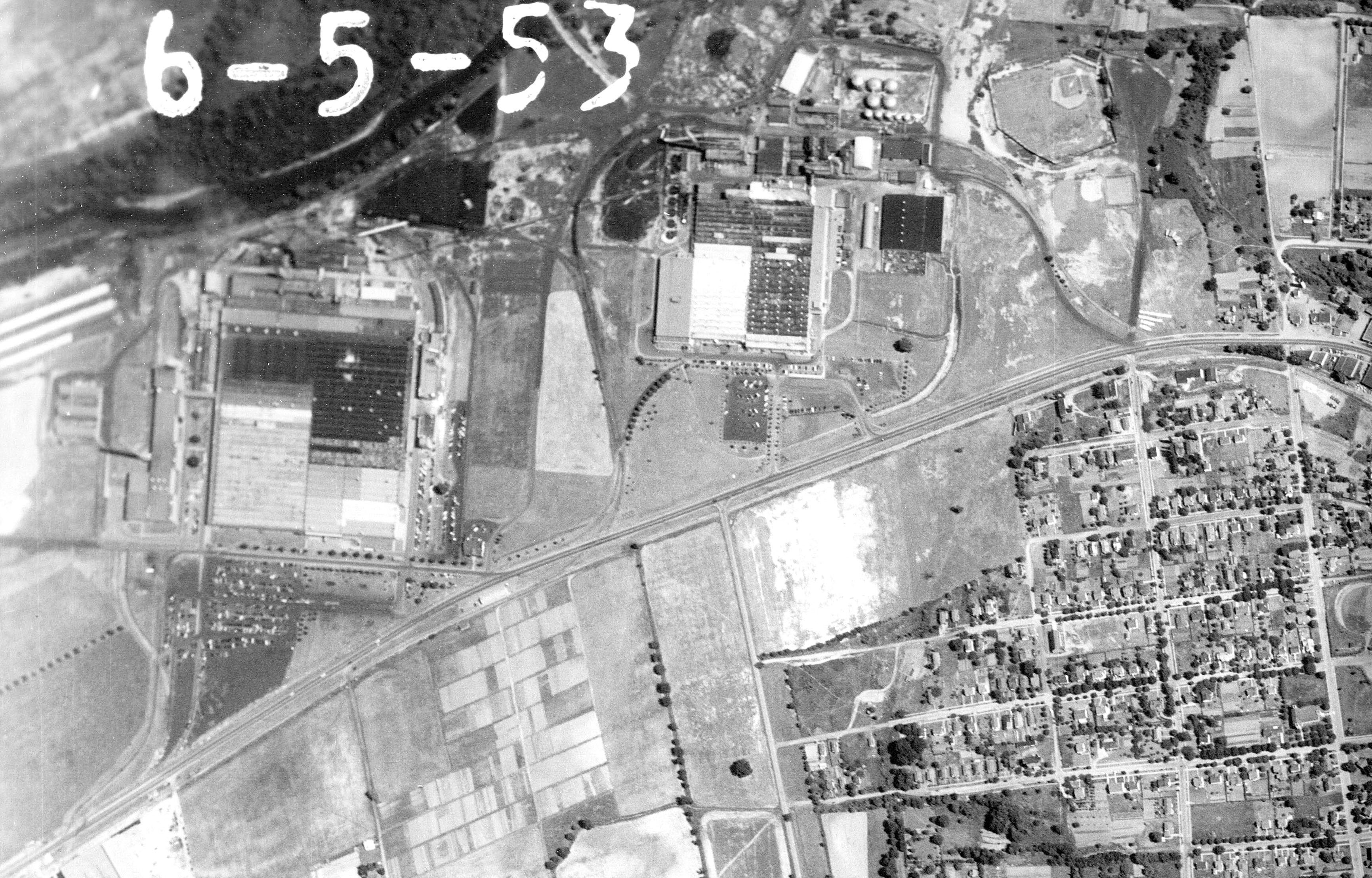
![]() This first photo is the main yard at JCity, depot on the left, enginehouse and all those other car shop buildings on the right, along with the ET truck terminal. Clinchfield (CC&O) line and the furnace spur in there too. Downtown JCity. The Southern line thru downtown. Just look around. That huge building just northwest of the enginehouse is the Burley tobacco warehouse, it's still there today. If the streets around the enginehouse don't look completely familiar, just remember that Legion Street as we know it today didn't exist then. Look for the Harris lumber southwest of the enginehouse, you'll recognize it from all the ventpipes and cyclones on the roof. Look downtown for the building with "Johnson City" and an arrow to the nearest airport spelled out on the roof (there's one in Elizabethton too). If anyone lived or has family in the older part of JCity, you may be able to find your homeplace. This photo has a companion photo that I'll mention in the next paragraph.
This first photo is the main yard at JCity, depot on the left, enginehouse and all those other car shop buildings on the right, along with the ET truck terminal. Clinchfield (CC&O) line and the furnace spur in there too. Downtown JCity. The Southern line thru downtown. Just look around. That huge building just northwest of the enginehouse is the Burley tobacco warehouse, it's still there today. If the streets around the enginehouse don't look completely familiar, just remember that Legion Street as we know it today didn't exist then. Look for the Harris lumber southwest of the enginehouse, you'll recognize it from all the ventpipes and cyclones on the roof. Look downtown for the building with "Johnson City" and an arrow to the nearest airport spelled out on the roof (there's one in Elizabethton too). If anyone lived or has family in the older part of JCity, you may be able to find your homeplace. This photo has a companion photo that I'll mention in the next paragraph.
![]()
![]() I'm going to list the companion photo to the above one. This photo sits on top of the previous one. The main reason I'm even putting this one in here is that I think it has the coolest thing I saw in all the 25-30 of these photos. The picture captured a Southern passenger train headed northeast out of JCity! It's getting ready to make the grade crossing at Broadway. That may not sound like much, but when you think about how they shot these photos (flying a north/south route snapping photos every few seconds, then moving over a little and repeating the procedure - kind of like mowing a yard but overlapping alot) the chances of catching anything interesting going on would be fairly slim. The next row of photos that I looked at did not show the train, it was either not there yet or gone already. Anyway the passenger train looks like 3 E units (1A and 2 Bs) pulling 12 cars, some with black roofs some with silver. You experts can tell me if I'm guessing correctly about the makeup of the train. The passenger train is passing an interesting yard with some cars sitting around, maybe an engine too. I think it's a Southern yard. This is a highly industrial section of town.
I'm going to list the companion photo to the above one. This photo sits on top of the previous one. The main reason I'm even putting this one in here is that I think it has the coolest thing I saw in all the 25-30 of these photos. The picture captured a Southern passenger train headed northeast out of JCity! It's getting ready to make the grade crossing at Broadway. That may not sound like much, but when you think about how they shot these photos (flying a north/south route snapping photos every few seconds, then moving over a little and repeating the procedure - kind of like mowing a yard but overlapping alot) the chances of catching anything interesting going on would be fairly slim. The next row of photos that I looked at did not show the train, it was either not there yet or gone already. Anyway the passenger train looks like 3 E units (1A and 2 Bs) pulling 12 cars, some with black roofs some with silver. You experts can tell me if I'm guessing correctly about the makeup of the train. The passenger train is passing an interesting yard with some cars sitting around, maybe an engine too. I think it's a Southern yard. This is a highly industrial section of town.
![]() The bottom of this photo matches up to the top of the previous photo. You can see Tannery Knobs (very visible in Downtown JCity) with the giant scar of a gravel pit (I think) on the southeast side. The big round thing on the lower Knob is not (contrary to popular belief) Ken's swimming pool at his palatial estate, it's one of JCity's reservoirs.
The bottom of this photo matches up to the top of the previous photo. You can see Tannery Knobs (very visible in Downtown JCity) with the giant scar of a gravel pit (I think) on the southeast side. The big round thing on the lower Knob is not (contrary to popular belief) Ken's swimming pool at his palatial estate, it's one of JCity's reservoirs.
==
![]() From Curtis Brookshire:
From Curtis Brookshire:
- The train in the Johnson City 2 photo should be Southern 46 the Tennessean, due out of JC around 9:25 am. The white colored roofs are streamlined cars, the dark roofs heavyweights. 45 and 46, originally completely streamlined, had mixed consists by this time. The head end cars are streamlined. They would later migrate to other trains, as the coaches were already doing.
![]() - I see no trace of the wye track. Looks like the truck terminal did a pretty good job of obliterating its remnants in the six years since narrow gauge operations moved from JC.
- I see no trace of the wye track. Looks like the truck terminal did a pretty good job of obliterating its remnants in the six years since narrow gauge operations moved from JC.
![]() Thanks for your insights into the photos. I think the eastern leg of the JCity wye is visible in the pic however. If you find the yard office (exactly where it is today) the wye went on both sides of it. The dark part of the yard (where the drive up to the office is today) is where the right hand leg of the wye was, cutting right next to the more modern carpenter shop buildings. The building in the photo that is the modern day building out at Legion Street at the end of the drive sits right where the car shed was, with the tail of the wye curving around it to avoid crossing the CC&O. I think you're right though, the truck terminal took the remaining leg of the wye.
Thanks for your insights into the photos. I think the eastern leg of the JCity wye is visible in the pic however. If you find the yard office (exactly where it is today) the wye went on both sides of it. The dark part of the yard (where the drive up to the office is today) is where the right hand leg of the wye was, cutting right next to the more modern carpenter shop buildings. The building in the photo that is the modern day building out at Legion Street at the end of the drive sits right where the car shed was, with the tail of the wye curving around it to avoid crossing the CC&O. I think you're right though, the truck terminal took the remaining leg of the wye.
![]() - Looks like plenty of business at the old depot in JC. Guess the vehicles parked at the front of the building are busses, maybe the vehicle at the east corner is a truck at the fuel pump? Looking at the orientation of the station to the Southern and ET&WNC tracks, it's easy to tell who had the most business when it was a union station.
- Looks like plenty of business at the old depot in JC. Guess the vehicles parked at the front of the building are busses, maybe the vehicle at the east corner is a truck at the fuel pump? Looking at the orientation of the station to the Southern and ET&WNC tracks, it's easy to tell who had the most business when it was a union station.
![]()
![]() This is Bemberg and NARC. These are from June 5, 1953 (which you'll see) and north is up. I've labeled all the usual stuff, but look around for other stuff. Look for the building in Elizabethton with the town name and airport location on the roof. I hear this was very common in small towns after WWII, don't know when they started doing this, possibly back in the 30's (?). Remember that what we see here is still a working railroad at the time the photos were shot, unlike Valley Forge, Hampton, etc.
This is Bemberg and NARC. These are from June 5, 1953 (which you'll see) and north is up. I've labeled all the usual stuff, but look around for other stuff. Look for the building in Elizabethton with the town name and airport location on the roof. I hear this was very common in small towns after WWII, don't know when they started doing this, possibly back in the 30's (?). Remember that what we see here is still a working railroad at the time the photos were shot, unlike Valley Forge, Hampton, etc.
==
![]() From Curtis Brookshire:
From Curtis Brookshire:
- I found no trace of the wye at Bemberg. That photo had poor resolution when zoomed in compared to others in this series, so its harder to identify details.
![]()
![]() I've labeled one spot in Elizabethton as the "extract industry/laurel fork ry". The Laurel Fork tracks started here (or ended here) at the Watuaga Extract complex, with various other wood related activities going on here also. I've labeled the location of the Elizabethton ET depot, but it looks like the depot is already gone and the present day concrete block building has already taken its place... although this is a dark place behind that building that could be where the depot had been - not sure. Not alot of exciting stuff going on in Elizabethton, just the juncture of several railroads and lots of small industries. You might want to check out my Elizabethton map in John Waite's book when you look at the aerial of the town, it'll probably make more sense. Eliz has always been easy to get lost in when doing map work for me.... too many streets at odd angles and nothing nice and square. Plus the railroad comes into town going east and leaves going south... kinda.
I've labeled one spot in Elizabethton as the "extract industry/laurel fork ry". The Laurel Fork tracks started here (or ended here) at the Watuaga Extract complex, with various other wood related activities going on here also. I've labeled the location of the Elizabethton ET depot, but it looks like the depot is already gone and the present day concrete block building has already taken its place... although this is a dark place behind that building that could be where the depot had been - not sure. Not alot of exciting stuff going on in Elizabethton, just the juncture of several railroads and lots of small industries. You might want to check out my Elizabethton map in John Waite's book when you look at the aerial of the town, it'll probably make more sense. Eliz has always been easy to get lost in when doing map work for me.... too many streets at odd angles and nothing nice and square. Plus the railroad comes into town going east and leaves going south... kinda.
![]() If you're looking for the famous transfer trestle of the late narrow gauge period of the ET, find the building with Johnson City written on top. The street adjacent to that building (to the left) is Division Street. Follow it down (south) until it ducks under the ET/Clinchfield tracks. That's the Division Street underpass built in 1922. On the north side of the tracks at the underpass go about a hundred feet to the right along side the tracks and you'll see a group of trees. On the north side of these trees you'll make out about 8-9 bents, I believe this is the remains of one of the coal transfer trestles that existed in this spot over many years. I think the much photographed one was just to the east of these bents, although I'll be danged if I can spot where it was exactly from this photo. It may have been where the bents are, but ground level photos from 1942 (only 10 years before this aerial was shot) show it to be directly on the north side of Harris Lumber. It would be hard to believe that this structure and trackwork wouldn't have left some impression that could still be seen only a few years later. What I'm sayin' is that it was right in this area, the "fog of research" is clearly evident here. Maybe someone who remembers seeing it can pinpoint the exact location. Also I'm not sure when the ET truck terminal was built, but it's possible that construction of it and its parking lot may have obliterated some of the leads to the coal trestle if it truly was on the east side of this area.
If you're looking for the famous transfer trestle of the late narrow gauge period of the ET, find the building with Johnson City written on top. The street adjacent to that building (to the left) is Division Street. Follow it down (south) until it ducks under the ET/Clinchfield tracks. That's the Division Street underpass built in 1922. On the north side of the tracks at the underpass go about a hundred feet to the right along side the tracks and you'll see a group of trees. On the north side of these trees you'll make out about 8-9 bents, I believe this is the remains of one of the coal transfer trestles that existed in this spot over many years. I think the much photographed one was just to the east of these bents, although I'll be danged if I can spot where it was exactly from this photo. It may have been where the bents are, but ground level photos from 1942 (only 10 years before this aerial was shot) show it to be directly on the north side of Harris Lumber. It would be hard to believe that this structure and trackwork wouldn't have left some impression that could still be seen only a few years later. What I'm sayin' is that it was right in this area, the "fog of research" is clearly evident here. Maybe someone who remembers seeing it can pinpoint the exact location. Also I'm not sure when the ET truck terminal was built, but it's possible that construction of it and its parking lot may have obliterated some of the leads to the coal trestle if it truly was on the east side of this area.
![]()
![]() Here's another photo. It's the Doe River Gorge on June 5, 1953. I scanned it as one piece rather than scanning it as 3 or 4 separate photos. Looks better, easier to follow, but it's about 7Mb so if you're on dial-up start it and go to bed.... sorry.
Here's another photo. It's the Doe River Gorge on June 5, 1953. I scanned it as one piece rather than scanning it as 3 or 4 separate photos. Looks better, easier to follow, but it's about 7Mb so if you're on dial-up start it and go to bed.... sorry.
![]() I've got the tunnels and bridges marked, along with the big scenic retaining wall, and the spot where Blevins Depot had stood. Also at the bottom of the photo there's a big long white smear.... that's highway 19E in the process of being built. You'll see the "old" highway weaving in and out of its path. That "old" highway is what is now the small access roads off of 19E back and forth into the residential areas along the "new" 19E highway. In fact when we later get to Crabtree in this series, you'll be able to count the supports on the highway bridge over Doe River that's under construction there.
I've got the tunnels and bridges marked, along with the big scenic retaining wall, and the spot where Blevins Depot had stood. Also at the bottom of the photo there's a big long white smear.... that's highway 19E in the process of being built. You'll see the "old" highway weaving in and out of its path. That "old" highway is what is now the small access roads off of 19E back and forth into the residential areas along the "new" 19E highway. In fact when we later get to Crabtree in this series, you'll be able to count the supports on the highway bridge over Doe River that's under construction there.
![]() If you look very closely at the Blevins Bridge, you can actually see the 3 "panels" of the top of the bridge - can't tell if they're silver or black though. If you look even closer you may be able to see Ken fishing off the bridge. Whoops, no, Ken wasn't born yet... must be somebody else.
If you look very closely at the Blevins Bridge, you can actually see the 3 "panels" of the top of the bridge - can't tell if they're silver or black though. If you look even closer you may be able to see Ken fishing off the bridge. Whoops, no, Ken wasn't born yet... must be somebody else.
![]() This photo is oriented a little different this time. North is actually up and to the right. If you'll look at the top right of the picture there's a diagonal black line... that's the top horizontal edge of the print so you should be able to orient yourself with it. The gorge actually runs from NNW to SSE. I scanned it this way to try to keep from including too much useless area around the gorge. I was able to then keep the file size down to a manageable size and include the whole gorge in one shot. For this aerial I scanned my 10" x 10" index photo. These index photos are actually same-size contact prints from the original negatives - so they're very sharp and clear. I was able to scan the print at 300% at 300 dpi and get similar results to what I was getting by scanning my 40" x 40" prints - with much less hassle.
This photo is oriented a little different this time. North is actually up and to the right. If you'll look at the top right of the picture there's a diagonal black line... that's the top horizontal edge of the print so you should be able to orient yourself with it. The gorge actually runs from NNW to SSE. I scanned it this way to try to keep from including too much useless area around the gorge. I was able to then keep the file size down to a manageable size and include the whole gorge in one shot. For this aerial I scanned my 10" x 10" index photo. These index photos are actually same-size contact prints from the original negatives - so they're very sharp and clear. I was able to scan the print at 300% at 300 dpi and get similar results to what I was getting by scanning my 40" x 40" prints - with much less hassle.
![]()
![]() I've uploaded the aerial of Crabtree and its index. This photo was taken September 28, 1953 (the shadows are much longer than the shadows from the June pictures) and it looks like this one was shot shortly before noon. North is up.
I've uploaded the aerial of Crabtree and its index. This photo was taken September 28, 1953 (the shadows are much longer than the shadows from the June pictures) and it looks like this one was shot shortly before noon. North is up.
![]() Crabtree is not terribly exciting, but it is the jumping on/jumping off point nowadays for the Old Railroad Grade Road scenic drive. The old photo makes it easier to see how the ROW came across 19E and then back on it, being swallowed up by the then new construction of 19E. Interesting to see that just beyond Crabtree to the east was the end of the new construction at that time. You can also see how the highway in that area pretty much sits on and covers up the ROW. The ROW does curve to the south of the highway and then back on it in one spot about midway along.
Crabtree is not terribly exciting, but it is the jumping on/jumping off point nowadays for the Old Railroad Grade Road scenic drive. The old photo makes it easier to see how the ROW came across 19E and then back on it, being swallowed up by the then new construction of 19E. Interesting to see that just beyond Crabtree to the east was the end of the new construction at that time. You can also see how the highway in that area pretty much sits on and covers up the ROW. The ROW does curve to the south of the highway and then back on it in one spot about midway along.
![]() The landmark church is there and you can probably see how modern-day Railroad Grade Road follows that little road on the west side of the church for a very short distance rather than exactly following the ET ROW. I suspect it was because the ROW was much lower than the highway and they used that little road to tie it in to the railroad ROW as it went north. The modern-day prison site is on up around the bend where the water tank was located in later years (check my map in John's book). Check out the highway bridge construction at the left end of the photo.
The landmark church is there and you can probably see how modern-day Railroad Grade Road follows that little road on the west side of the church for a very short distance rather than exactly following the ET ROW. I suspect it was because the ROW was much lower than the highway and they used that little road to tie it in to the railroad ROW as it went north. The modern-day prison site is on up around the bend where the water tank was located in later years (check my map in John's book). Check out the highway bridge construction at the left end of the photo.
![]() The right end of the photo shows the west end (suburbs?) of Roan Mountain (our next stop on the journey down memory lane). Enjoy.
The right end of the photo shows the west end (suburbs?) of Roan Mountain (our next stop on the journey down memory lane). Enjoy.
![]()
![]() Here's another photo, Roan Mountain. As with Crabtree, this one was shot September 28, 1953 shortly before noon. North is up. You'll notice nice evenly spaced dots in the fields, I'm assuming this is hay since it's September. Not really alot to see in this photo but you can get a feel for where the railroad was by locating SB Woods drugstore (which is still there), the buildings where there are antique shops today, and you can see the dark spot where the depot stood. I've also marked the area where the Roan Mountain Inn stood, but I think it had been gone for many years when this photo was taken. You can tell there was a passing siding in "downtown" Roan Mtn, you can see the adjacent track peek out every now and then. Note for Philip, check out the road bridge over the Doe south of the depot... it's silver, no doubt about it.
Here's another photo, Roan Mountain. As with Crabtree, this one was shot September 28, 1953 shortly before noon. North is up. You'll notice nice evenly spaced dots in the fields, I'm assuming this is hay since it's September. Not really alot to see in this photo but you can get a feel for where the railroad was by locating SB Woods drugstore (which is still there), the buildings where there are antique shops today, and you can see the dark spot where the depot stood. I've also marked the area where the Roan Mountain Inn stood, but I think it had been gone for many years when this photo was taken. You can tell there was a passing siding in "downtown" Roan Mtn, you can see the adjacent track peek out every now and then. Note for Philip, check out the road bridge over the Doe south of the depot... it's silver, no doubt about it.
![]()
![]() Here's Shell Creek for Julia and all the rest of you. This photo was made September 17, 1953 a little before noon. Unfortunately, the left side of the photo was the edge of my print, and all these prints are soft around the edges, probably from fall-off at the edge of the negatives. I've marked the place where the sawmill of today is on the photo. The boxcar that Ken moved to Elizabethton sat at this mill for years. There was a steel thru truss bridge across Buck Creek (Buck flows into the Doe back at Roan Mtn.) here at this mill. Shell Creek (the creek) crossed the ROW and the highway on the west side of the depot and merged with Buck Creek up by the mill. Buck Creek was called Wilson Creek way back in the ET days.
Here's Shell Creek for Julia and all the rest of you. This photo was made September 17, 1953 a little before noon. Unfortunately, the left side of the photo was the edge of my print, and all these prints are soft around the edges, probably from fall-off at the edge of the negatives. I've marked the place where the sawmill of today is on the photo. The boxcar that Ken moved to Elizabethton sat at this mill for years. There was a steel thru truss bridge across Buck Creek (Buck flows into the Doe back at Roan Mtn.) here at this mill. Shell Creek (the creek) crossed the ROW and the highway on the west side of the depot and merged with Buck Creek up by the mill. Buck Creek was called Wilson Creek way back in the ET days.
![]() I've marked where the depot was, and circled the school building that is still there. Not sure what school it was, but I understand it was also used as a meeting hall for a Masonic Temple. Maybe Julia can clue us in on other uses for that building.
I've marked where the depot was, and circled the school building that is still there. Not sure what school it was, but I understand it was also used as a meeting hall for a Masonic Temple. Maybe Julia can clue us in on other uses for that building.
![]() The higway looks freshly blacktopped as it parallels the ROW thru this area. The east end of the photo is the far west end of Stateline Hill, although I'm not sure where it officially started.
The higway looks freshly blacktopped as it parallels the ROW thru this area. The east end of the photo is the far west end of Stateline Hill, although I'm not sure where it officially started.
![]()
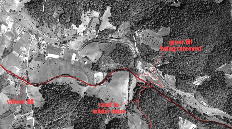
![]() Just posted a photo of the Wilcox Fill/Greer Fill section of State Line Hill. This photo was from September 17, 1953. North is up and it's shortly before noon. Both of these fills crossed large areas and had road underpasses built under them. Greer Fill was the larger of the two. The abutments for the underpasses are clearly visible in the photo at both fills. The abutments at Greer are still there and can be walked to right off 19E along part of the Appalachian Trail. The underpass at Greer was for a truck road leading to the Wilder mine (not visible, but just south of the bottom of the photo). You can see equipment at Greer fill taking out the fill and crushing it for highway use. See page 247 in John Waite's book for a good photo of that operation going on. Greer fill was about (I'm guessing here) about 300 feet long and had a large rectangular concrete culvert built underneath it. And don't let this photo fool you, these fills along this area are very high, much more dramatic than they appear here.
Just posted a photo of the Wilcox Fill/Greer Fill section of State Line Hill. This photo was from September 17, 1953. North is up and it's shortly before noon. Both of these fills crossed large areas and had road underpasses built under them. Greer Fill was the larger of the two. The abutments for the underpasses are clearly visible in the photo at both fills. The abutments at Greer are still there and can be walked to right off 19E along part of the Appalachian Trail. The underpass at Greer was for a truck road leading to the Wilder mine (not visible, but just south of the bottom of the photo). You can see equipment at Greer fill taking out the fill and crushing it for highway use. See page 247 in John Waite's book for a good photo of that operation going on. Greer fill was about (I'm guessing here) about 300 feet long and had a large rectangular concrete culvert built underneath it. And don't let this photo fool you, these fills along this area are very high, much more dramatic than they appear here.
![]() The underpass at Wilcox fill was for a county road. One abutment, the eastern one is still standing, but the western abutment and all the fill on that side is now gone, but was still intact in 1953.
The underpass at Wilcox fill was for a county road. One abutment, the eastern one is still standing, but the western abutment and all the fill on that side is now gone, but was still intact in 1953.
![]() We walked from the right side of this photo down to Wilcox fill a few years ago at the convention. Some pretty tight curves and a continuous grade in this area. We're not too far from Elk park on the eastern end of this photo.
We walked from the right side of this photo down to Wilcox fill a few years ago at the convention. Some pretty tight curves and a continuous grade in this area. We're not too far from Elk park on the eastern end of this photo.
![]()
![]() Got a unique opportunity here with Elk Park, and with Cranberry too, my next photo. I have aerials from March 6, 1952 and also a year and a half later on September 18, 1953 at 10:42 am (the photo was time stamped). North is up. We get to see how fast things changed in a short period of time with the coming of the new highway. And we can now see aerials shot while the foliage is down. I've juxtaposed both aerials into one photo (one above the other) so that you can easily scroll up and down and check out the differences in the 2 years photos.
Got a unique opportunity here with Elk Park, and with Cranberry too, my next photo. I have aerials from March 6, 1952 and also a year and a half later on September 18, 1953 at 10:42 am (the photo was time stamped). North is up. We get to see how fast things changed in a short period of time with the coming of the new highway. And we can now see aerials shot while the foliage is down. I've juxtaposed both aerials into one photo (one above the other) so that you can easily scroll up and down and check out the differences in the 2 years photos.
![]() The main difference between them is that the highway was straightened and improved during this time. In 1952 you can clearly see the ET ROW coming into Elk Park from the west, coming thru town and leaving to the east. The new highway was put down right on top of the ROW and stays that way until the highway leaves to the east and the ROW curves off to the SE and becomes modern-day Iron Street. In 1952 the main highway was the street that dips down and runs right in front of the downtown buildings and goes on to become basically a residential street. I've marked the depot site (should be able to see the light colored place in 1952), Time Square Diner, the station shelter at the top of the hill above Cranberry and the Superintendant's house (which is still standing - but only in the most literal sense). And while you're here, check out the burned down (or torn down) building foundation in downtown. I'll bet somebody on the list knows what business this was and when it disappeared.
The main difference between them is that the highway was straightened and improved during this time. In 1952 you can clearly see the ET ROW coming into Elk Park from the west, coming thru town and leaving to the east. The new highway was put down right on top of the ROW and stays that way until the highway leaves to the east and the ROW curves off to the SE and becomes modern-day Iron Street. In 1952 the main highway was the street that dips down and runs right in front of the downtown buildings and goes on to become basically a residential street. I've marked the depot site (should be able to see the light colored place in 1952), Time Square Diner, the station shelter at the top of the hill above Cranberry and the Superintendant's house (which is still standing - but only in the most literal sense). And while you're here, check out the burned down (or torn down) building foundation in downtown. I'll bet somebody on the list knows what business this was and when it disappeared.
![]() The station shelter is also gone by 1953.
The station shelter is also gone by 1953.
![]() To the right of Time Square Diner is a road headed NE. On the east side of that road was a lake formed from Cranberry Creek which flows NE at this spot. The lake was the site of the very original iron forge for Cranberry. The lake supplied power for a wheel driven bellows. The forge was later removed and a more modern iron furnace was built down to the south at the Cranberry mine.
To the right of Time Square Diner is a road headed NE. On the east side of that road was a lake formed from Cranberry Creek which flows NE at this spot. The lake was the site of the very original iron forge for Cranberry. The lake supplied power for a wheel driven bellows. The forge was later removed and a more modern iron furnace was built down to the south at the Cranberry mine.
![]() If I knew exactly where "Dark Holler" was I would have marked it.
If I knew exactly where "Dark Holler" was I would have marked it.
==
![]() The foundation I was talking about is in the row of downtown Elk Park buildings. You can't miss it in the 1953 photo, about middle of the row of store fronts.
The foundation I was talking about is in the row of downtown Elk Park buildings. You can't miss it in the 1953 photo, about middle of the row of store fronts.
![]() I've always wondered about where the Hotel was too. Any ideas? I can look for a bald spot on the aerials if you have a general area to search.
I've always wondered about where the Hotel was too. Any ideas? I can look for a bald spot on the aerials if you have a general area to search.
==
![]() Mike Hardin:
Mike Hardin:
Going from memory it was in the heart of Cranberry about 5 or 6 buildings up from the Church going up the road toward Newland. The steps are still there.
==
![]() That hotel is on the company survey maps. I included it on my Cranberry map in John's book, but didn't label it. On the aerial photos of Cranberry from 1952 (which you'll see shortly) there's a 5-6 house gap in the line of company houses there where the hotel stood. Maybe when it burned it took its neighbors with it. I was under the impression that there was 2 different hotels over the years...
That hotel is on the company survey maps. I included it on my Cranberry map in John's book, but didn't label it. On the aerial photos of Cranberry from 1952 (which you'll see shortly) there's a 5-6 house gap in the line of company houses there where the hotel stood. Maybe when it burned it took its neighbors with it. I was under the impression that there was 2 different hotels over the years...
==
![]() Yes, there were two. The first one was down by the high school when the railroad started then the second one was built up by the church. Mike.
Yes, there were two. The first one was down by the high school when the railroad started then the second one was built up by the church. Mike.
![]()
![]() Got another aerial, this time it's Cranberry on March 6, 1952. North is up. The foliage being down really lets the ROW stand out, just like seeing it from ground level in the fall and winter. I've marked a good bit of stuff on the index photo this time. And the photo goes from the wye down to Tucker Branch, the official end of the ET&WNC and the beginning of the LRRy. The time of year really makes the surface diggings of the mine stand out in contrast to the undisturbed mountainside. The low angle of the sun probably has that effect also. I have the same area in a photo from Sept. of 1953 and it is much harder to see the mine and the ROW also. You'll note in the 1952 photo that Cranberry depot is still intact. It was gone in Sept. of 53, but I don't know what year it was torn down.
Got another aerial, this time it's Cranberry on March 6, 1952. North is up. The foliage being down really lets the ROW stand out, just like seeing it from ground level in the fall and winter. I've marked a good bit of stuff on the index photo this time. And the photo goes from the wye down to Tucker Branch, the official end of the ET&WNC and the beginning of the LRRy. The time of year really makes the surface diggings of the mine stand out in contrast to the undisturbed mountainside. The low angle of the sun probably has that effect also. I have the same area in a photo from Sept. of 1953 and it is much harder to see the mine and the ROW also. You'll note in the 1952 photo that Cranberry depot is still intact. It was gone in Sept. of 53, but I don't know what year it was torn down.
![]() Check out Smokey Street and look at the photo on page 87 of John Waite's book that shows the same road. It was covered at one time with company houses of two varieties. A single story, single family, and a 2 story, 2 family. In the aerial you can see just 3 houses left, a single story on the north side of the street and two 2-story houses on the south side. Today, the 2 houses I circled are still there to see if you want to model some off-the-shelf company houses.
Check out Smokey Street and look at the photo on page 87 of John Waite's book that shows the same road. It was covered at one time with company houses of two varieties. A single story, single family, and a 2 story, 2 family. In the aerial you can see just 3 houses left, a single story on the north side of the street and two 2-story houses on the south side. Today, the 2 houses I circled are still there to see if you want to model some off-the-shelf company houses.
![]() The main road thru town is also lined with company houses. I've marked the Baptist church, which has always been a landmark for determining directions and locations in the old photos. There's a gap of about 5-6 houses on the south side of the church, apparently where the hotel had been and had burned at one time.
The main road thru town is also lined with company houses. I've marked the Baptist church, which has always been a landmark for determining directions and locations in the old photos. There's a gap of about 5-6 houses on the south side of the church, apparently where the hotel had been and had burned at one time.
![]() You'll notice that the entrance to the mine stands out clearly. It has collapsed or the top has been taken off since the rails have been removed. I kinda think that the mine entrance never had much of a top, I think that it was so close to the height of the mainline track over it that they just bridged over it and when the rails were removed the gap showed up. I know when we've visited the mine area there are steel girders in the ground over the gap that was the entrance. Note too that the entrance is perpendicular to the actual mine itself. You can still walk the ROW from the mine past the pond to the wye and on in to Elk park today.
You'll notice that the entrance to the mine stands out clearly. It has collapsed or the top has been taken off since the rails have been removed. I kinda think that the mine entrance never had much of a top, I think that it was so close to the height of the mainline track over it that they just bridged over it and when the rails were removed the gap showed up. I know when we've visited the mine area there are steel girders in the ground over the gap that was the entrance. Note too that the entrance is perpendicular to the actual mine itself. You can still walk the ROW from the mine past the pond to the wye and on in to Elk park today.
![]() I've marked the site of the mine buildings which had been gone over 20 years when this photo was taken. Also the area where the enginehouse and facilities were. The company store is still going and would stand until the early eighties when it burned. You can still see the outline of the tennis courts in the field on the south side of the store.
I've marked the site of the mine buildings which had been gone over 20 years when this photo was taken. Also the area where the enginehouse and facilities were. The company store is still going and would stand until the early eighties when it burned. You can still see the outline of the tennis courts in the field on the south side of the store.
==
![]()
![]()
![]()


©2005 blanchard design,
all rights reserved
![]()


